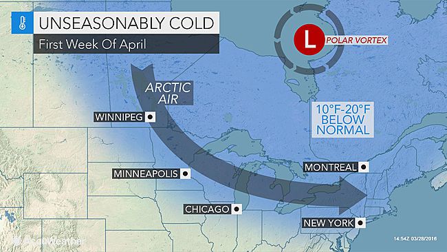
A southward plunge of the polar vortex will bring a quick blast of arctic air directed at the Great Lakes and northeastern United States during the first week of April.
“The latest indications are the core of the coldest air associated with the polar vortex will track a bit farther north and east, compared to the outlook from last week,” according to AccuWeather Long-Range Meteorologist Edward Vallee.
The main thrust of cold air will aim at the Great Lakes, New England and the northern part of the mid-A
There is still a chance the arctic air may sneak farther south at the last minute, according to AccuWeather Long-Range Meteorologist Joe Lundberg.
It is possible for frost and freezing temperatures at night in parts of the central Plains, Tennessee Valley and southern Piedmont areas at the height of the cold air.
The potential for shocking cold and a hard, damaging freeze will exist from the Upper Midwest to the interior Northeast.
We use cookies to optimize our website and our service.
Functional cookies Always active
The technical storage or access is strictly necessary for the legitimate purpose of enabling the use of a specific service explicitly requested by the subscriber or user, or for the sole purpose of carrying out the transmission of a communication over an electronic communications network.
Preferences
The technical storage or access is necessary for the legitimate purpose of storing preferences that are not requested by the subscriber or user.
Statistics
The technical storage or access that is used exclusively for statistical purposes.The technical storage or access that is used exclusively for anonymous statistical purposes. Without a subpoena, voluntary compliance on the part of your Internet Service Provider, or additional records from a third party, information stored or retrieved for this purpose alone cannot usually be used to identify you.
Marketing
The technical storage or access is required to create user profiles to send advertising, or to track the user on a website or across several websites for similar marketing purposes.
and east, compared to the outlook from last week,” according to AccuWeather Long-Range Meteorologist Edward Vallee.